
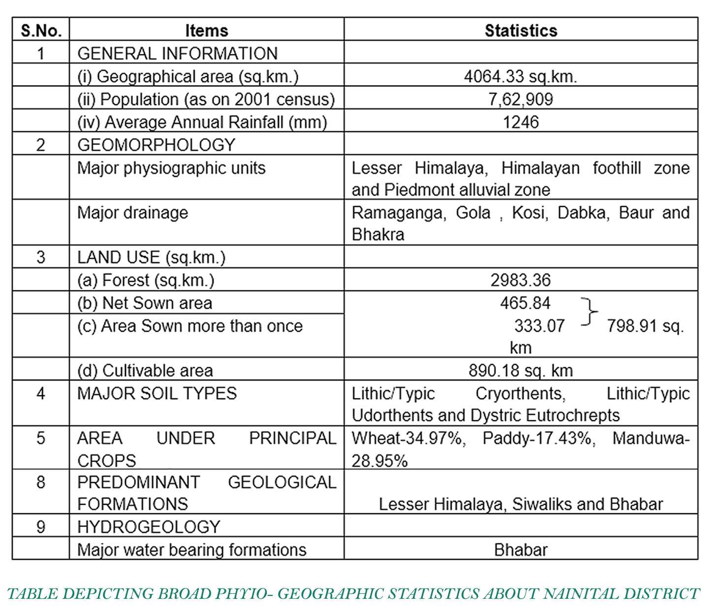
Physiographic , Physio- Topographic & Physio- Hydrogical Statistics of Nainital
Physiographic , Physio- Topographic & Physio- Hydrogical Statistics of Nainital
A CASE STUDY OF PHYSIOLOGICAL TERRAINS OF NAINITAL DISTRICT
Landscape Architecture Design Series I Ar. Ankur Gautam, Gautam & Gautam Associates I 2 MAY, 2020
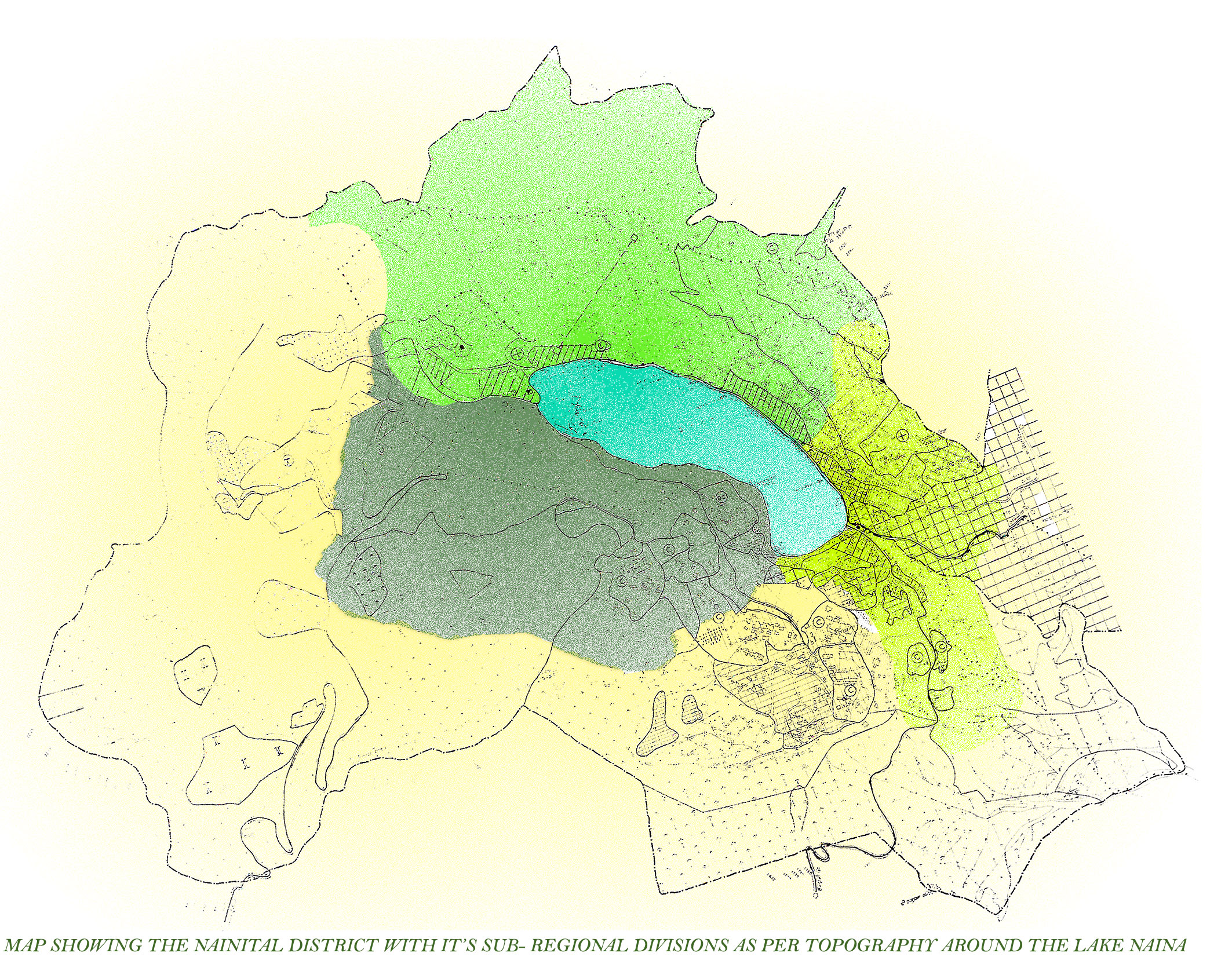
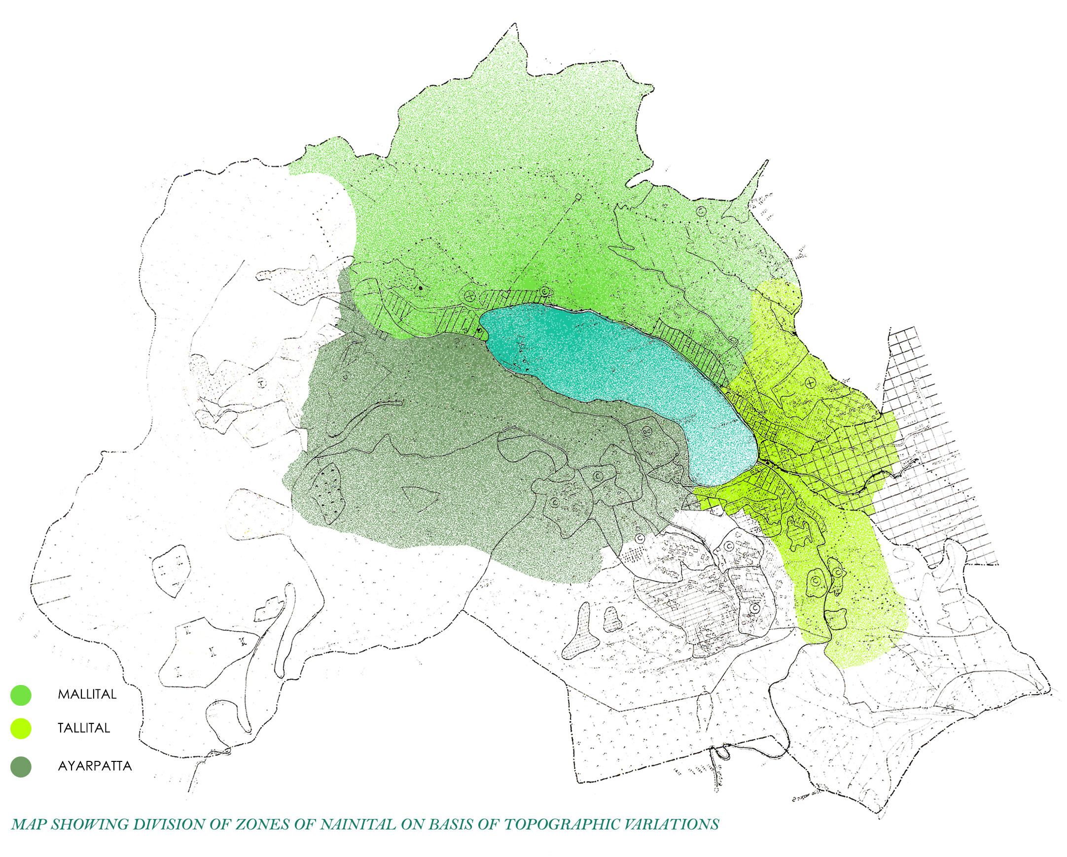
The city is set in a valley around the Nainital Lake – an eye-shaped lake, which is located at an altitude of 1,940 m (6,350 ft) from sea level. Geographically, the town can be divided into THREE parts – Mallital, Tallital, Ayarpatta
Mallital is the northern side of the lake and Tallital is the southern fringes of the lake, Ayarpatta forming the WESTERN SIDE.
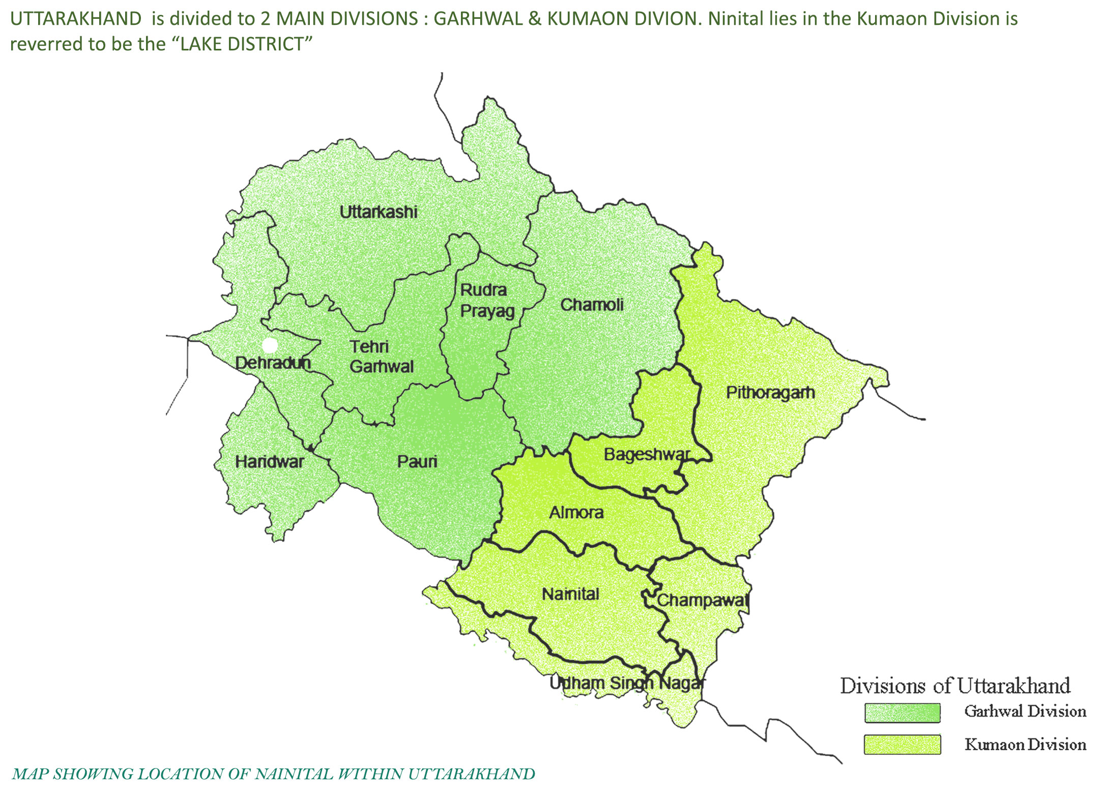
The district is named as the Lake District of Uttarakhand since it is situated close to the Naini Lake in the state. The name of the lake originated from the name of Naina Devi, a popular deity in the area.
The city of Nainital covers a total area of 11.73 km2 (4.53 sq mi), and is located at 29.38°N 79.45°E,at an average elevation of 2,084 metres (6,837 ft) above sea level. The slopes of the nearby mountains are most populated, with an elevation ranging from 1,940–2,100 m (6,360–6,890 ft). The highest point nearby is the Naina Peak or China Peak, with an elevation of 2,619 m (8,593 ft). The city is located in the Kumaon foothills of the outer Himalayas at a distance of 285 km (177 mi) from the state capital Dehradun and 345 km (214 mi)
from New Delhi, the capital of India.
The lake is 1,433 m (1,567 yd) long and 463 m (506 yd) wide, and is approximately two miles in circumference. The bed of the lake is at a depth of 85 m (93 yd) near Pashandevi, the deepest point of the lake. The lake is deduced to have been formed tectonically. Balia Nala, which is the main stream feeding the lake is along a fault line and the subsequent streams align parallel to major joints and faults. 26 major drains feed the lake including the 3 perennial drains.
Nainital is surrounded by the mountains of Ayarpata (2,344 m (7,689 ft), Devpata (2,435 m (7,989 ft),Hanibani (2,180 m (7,153 ft), China (2,612 m (8,568 ft), Alma (2,430 m (7,980 ft), Ladiya Kanta (2,482 m (8,144 ft) and Sher ka Danda (2,398 m(7,869 ft).
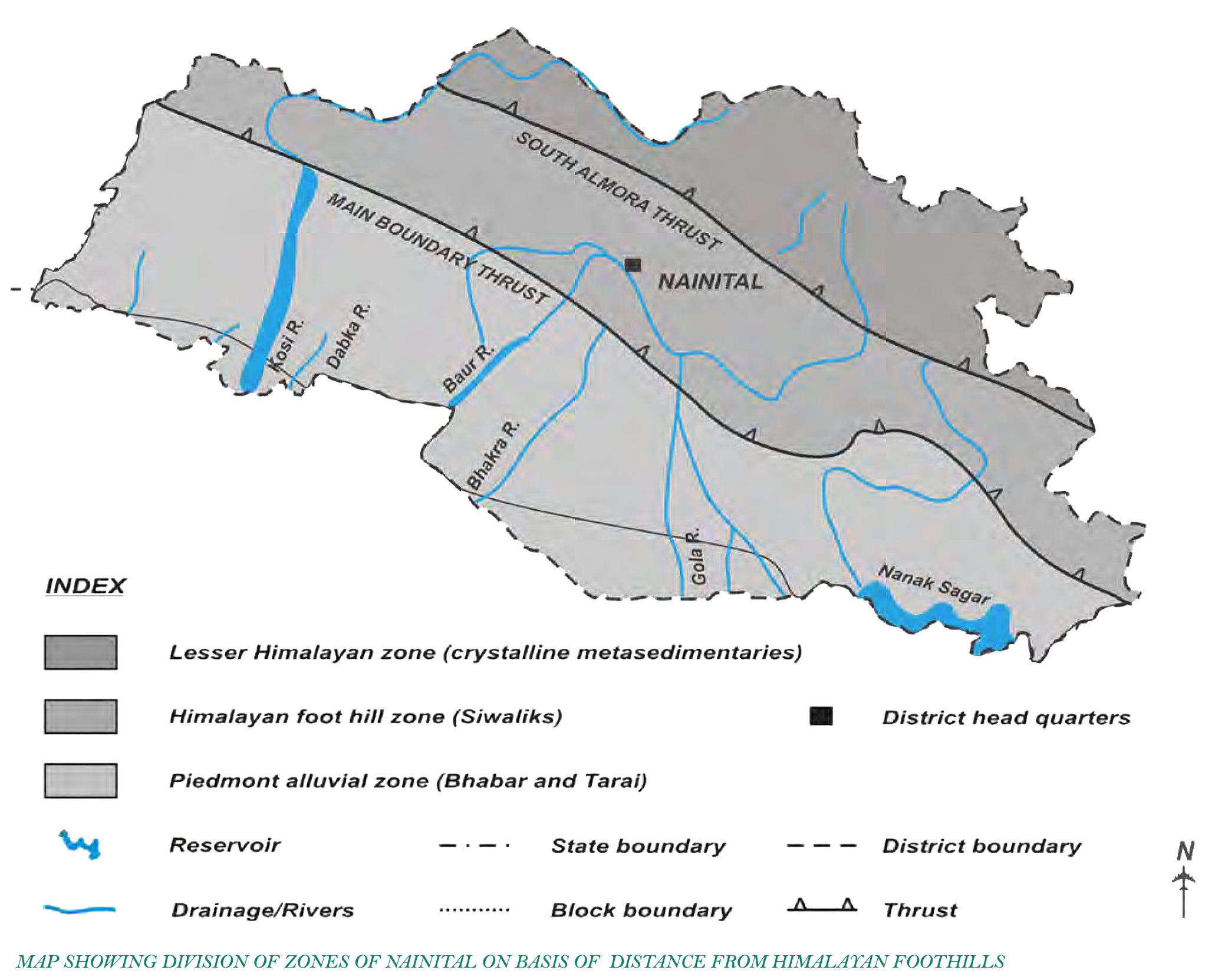
NAINITAL can be sub- divided into 3 ZONES further based on the distance from Himalayan foothills :
Lesser Himalayan Zone – separated by South Almora Thrust
Himalayan Foothill Zone – just next to the Himalayan belt
Piedmont Alluvial Zone – farthest away from the Himalayas
The Thrusts acts as the highest points in Elevations, regulating the topography within.
Lesser Himalaya: The Lesser Himalayan formations occupy an almost one-third area of the district. The main rock types are granite, granodiorite, phyllites, slates, quartzites, schists and gneiss. The Krol and Blaine formations comprise mainly of sandstones, limestones and quartzites.
Outer Himalayan Foothill Zone: This zone can be classified into the Lower Siwaliks, Middle Siwaliks and the Upper Siwaliks. Lower Siwaliks: The lower Siwaliks are characterized by hard, massive, grey to brownish-grey sandstones interbedded with grey to maroon clays. They form the outermost zone in the Nainital Himalayas and occasionally exhibit local structural discontinuities. The dip is usually northwards. Middle Siwaliks: The middle Siwaliks are characterized by massive light grey micaceous sandstones.
Upper Siwaliks: The Upper Siwaliks are constituted of pebbles, cobbles, boulders, conglomerates and clay lenses. The pebbles and boulders are mostly quartzitic. Thin lenses of grey to light green colour clays are common.
Intermontane Valleys: Small (~ 25 km long and 10 km wide) intermontane valleys locally known as “Kota Doon” occur within the Sub-Himalayan Siwaliks trending in NNW-SSE direction. The epispastics mainly comprise of boulders, pebbles, cobbles, granules, sands & clays of varied composition.
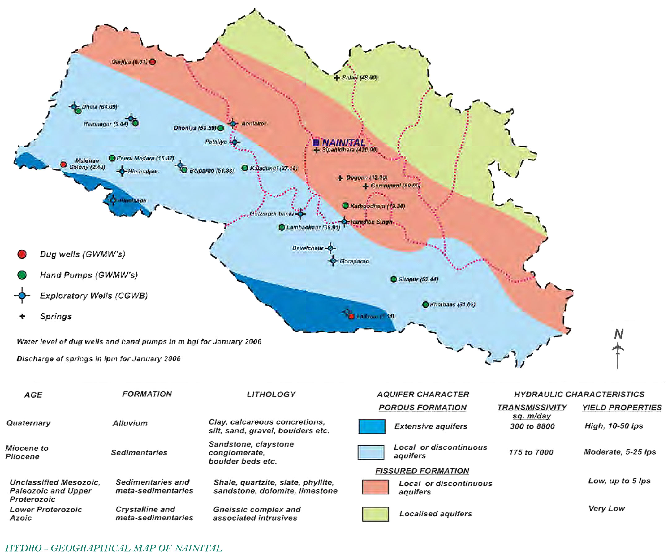
Piedmont Alluvial Plains: This zone is broadly classified into the Bhabar and Tarai formations, which are separated by the spring line.
Bhabar Formation: The formation is mainly comprised of poorly sorted unconsolidated sediments viz, cobbles boulders, gravel, pebbles, sand and silt with intervening clay layers. Clay lenses are of limited extent. The belt exhibits NW-SE elongation. The width of the belt is quite variable. The maximum width (about 21km) is in Haldwani – Kichha (Udham Singh Nagar) section.
Tarai Formation: Tarai formation consists of sand, clay, silt, sandy clays and occasionally gravel. Clay beds predominate over sand beds. The northern limit of the belts is the spring line, separating it from Bhabar.
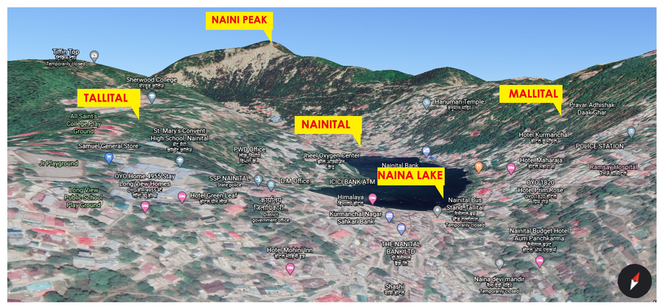
3d Topographic Image depicts Naini Peak at highest level in Kumaon region of Uttarakhand, with Tallital & Mallital at peripheral
East & West terrains higher than Nainital, the lowest level of the three, situated right next to the NAINA LAKE, with Ayarpatta defining the southern periphery of the lake , further descending to further lower terrain zones.
FOR DETAILED INSIGHT TO OUR LANDSCAPE PROJECTS, VISIT :
Copyright © 2023 All rights reserved.
Developed by Abacus Desk