Historic Cultural Waterwork Identity of Delhi- Haryana Ridge : Suraj Kund Complex : Peacock Lake & Anangpur Dam

Historic Cultural Waterwork Identity of Delhi- Haryana Ridge : Suraj Kund Complex : Peacock Lake & Anangpur Dam
A STUDY OF THE EARLIEST WATERWORKS OF SURAJKUND – LAKE PEACOCK & ANANGPUR DAM IN FARIDABAD & ANALYSIS ON FACTORS RESPONSIBLE FOR THEIR DETERIORATION
Landscape Architecture Design Series I Gautam & Gautam Associates I Ar. Ankur Gautam I 12 MAY, 2020
HISTORICAL CONTEXT OF SURAJKUND REGION
Towards the end of the First Milemium CE, early surviving waterworks are found on the Southern side of the Ridge fromAnangpur Dam (c.8th c.CE) downstream to SurajKund (c.1000 CE), including a terraced, semi- circular tank named jointly for it’sbuilder : SURAJ PAL TOMAR, whose name invoked the Sun (Surya) and it’s water tank (KUND). Edges of the stone- lined tankremain, restored in the Tughluq period and after, some 3 centuries later.

This site and most of the Sultanate cities and waterworks that followed, aligned themselves with the Ridge and it’s runoff.Strategically, the Ridge cities controlled the waters, the roads and the uplands of Delhi. The Southern Ridge and more precisely,the junction between the southern and central ridge became the preferred area for urban water development.
The first surviving city of Delhi, known as LAL KOT, was built by the Tomars in the 9th- 12th Centuries in the Mehrauli area astheir capital, at the time of the construction of Suraj Kund. In Haryana, during the Tomar’s reign, the region saw extensivewaterworks, starng from Anangpur dam, having downstream as Lake Peacock, connecting to the Surajkund- The water tank ofthe Sun.

The Three Major Cities Of Delhi in 1982, With LAL Kot Being The Earliest Waterwork Established City, Also Consisting Of Present Day Ridge Credits: Cherian 2004, PG:44
THE SURAJ KUND : A BRIEF PHYSIOLOGICAL HISTORICAL DESCRIPTION
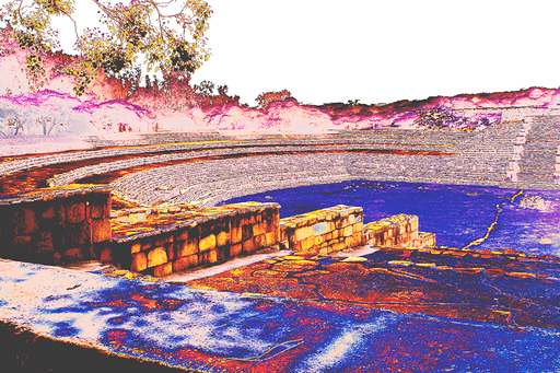
SURAJ- KUND ( Surya- pushkarini) , located about 3 km south- east of Delhi’s Tughluqabad Fort, in Faridabad district of Haryanaresembles a Roman amphitheatre built in 6 Acres of land. It is a stepped stone embankment approx. 12 Metres deep. It has asemi- circular plan, like a rising sun curving Eastwards. It was meant to invest rainwater & store it from the Aravallis. Thisreservoir is linked to an ancient channel through a lake – Peacock Lake (also called Surajkund lake) .(2)

Firuz Shah Tughluq (1351-88), the third ruler of Tughluq Dynasty of Delhi Sultanate, took keen interest in the conservation ofwater structures around Delhi. He repaired steps & terraces of the Kund by laying Lime- Concrete over them. Later, a smallfortified enclosure, called Garhi, was raised above the western bank of the Kund around the traditional site of the temple.
It is believed that a Sun temple existed on it’s West level of the Kund. It is believed that a Sun Temple existed on it’s west ascertain carved stones from the temple were recently retrieved from the reservoir & some are found re-used in laterconstructions. The image below depicts the remains of the Sun temple, still present.

LAKE PEACOCK IN CONTEXT TO SURAJKUND FROM BEING PERENNIAL TO A DEAD LAKE
Surajkund Lake also known as the ‘Peacock Lake’ : as the profile of edges of lake mimic the peacock’s head & neck with the SurajKund, being the stalk above the head. The lake was originally a water tank and an ancient reservoir and next to it is a semicircleembankment shaped like an amphitheatre and the ruins of a Sun Temple on the western banks of the Lake; all built in the 10thCentury by King Surajpal of the Tomar dynasty who avidly worshipped the Sun God. The Lake is situated close to Badkhal Lake,2 km from an ancient 8th Century AnagpurDam or the Arangpur Dam and 8 Km from South Delhi. It was named after the ‘SunGod’ and means ‘The Sun Lake’ that offers tourists with a lovely picnic spot and a picturesque scene of the Aravalli Hills. From the 1st to the 15th of February, this place comes alive with the Surajkund Mela or Fair that fills the area with beautifulsculptures, art work, handicrafts and handloom work displayed by the artists themselves and available for purchase at a very less price.

The context of the historical Waterworks was initially only demarcated by high density local villages. But due to gradualurbanization in the context and the proximity to a natural waterscape, certain low density residential apartments startedestablishing, some just as close to 3m from lake & others following the setback norms. Due to presence of Surajkund complexnearby, the Surajkund Mela was conceptualized just adjacent to thisprecinct, to highlight the cultural landscapes of the region,as well as symbolizing cultural unity in diversity. These activities gradually attracted the commercial & hospitality landusesatthe peripheries of the Mela ground, like Taj Vivanta Hotel, Rajhans& Business tower.

The maximum mean sea level recorded for Solid Quartzite Rock nearby the lake were 290 m to 240m stretched in 2.7 km ofarea in Aravalli Ridge area and in Fractured Quartzite Rock area a maximum elevation of 240m to 222 m is covered in 2.18 kmof area at Surajkund Lake reservoir .Thus Solid Quartzite Rock is found to have very steep gradient of 18.5 m/km whereasFractured Quartzite Rock has a comparatively less but still steep gradient of 8.2 m/km.In this way, it is evident that overall onan average a steep gradient is established and average gradient shows that the area has got hilly topography, by virtue of whichthe existence of lake was possible.(3)

THE MINING, ILLEGAL ENCROCHMENT & RAPID URBANIZATION HAZARD
The Google earth image timeline depicts the effect of ruthless & uncontrolled mining around the Lake & the Kund, affecting the slope of the surrounding Aravali mountains, destroying the inclination required for monsoon rain water to seep down & stream in the lake , to be further collected to the kund. The ANANGPUR DAM, located right at the inception of Lake Peacock, forms the reservoir from where the water is released into the Catchment Zone (Lake), which further connects to the Suraj Kund. This Waterwork establishment served as a vital source for household water requirement for the remote villages like Anangpur, which now ceases to exist.
The Kund served to control flood water and soil erosion in the area also. These two lakes :Peacok&Badkal, were largely fed by rainwater and needed the catchments to be maintained in order to retain good water levels throughout the year. According to a study by the Geological Survey of India & the above timeline, mining activities, over the years, have denuded the catchments areas, which led to soil erosion and increased runoff without recharging the groundwater. The mining has left mining pits and as a result the rainwater fills up the pits and not the lakes. The mining has also led to destruction of the Aravalli vegetation, extremely between the Ridge on Gurugram side & Ridge extending towards South Delhi. It is evident in the timeline images, the disastrous effect the mining has on local flora & fauna. The earliest documented mining activities incepted about in 1998 and started hindering the natural topography of the context around the waterscape. Not soon in 2002, the effect of mining erased about 90 % of the dense vegetation around the lake &kund. This resulted in immense soil erosion near the waterscape, preventing flourishment of new flora. Also, time & again continuous mining for Granite, Quartzite & other stones, reduced gradually the fertility of the soil & loose soil particles in air, leading to air pollution. The destruction of dense vegetation on the hills also increased the Heat Island Effect in the surrounding areas by almost double. The lost vegetation also, used to harbour rains in the local region, leading to lake being perennial. But due to deforestation, the rainfall in the region has observed an annual decline of about 30%. Not only rainfall, the vegetation also acted as a barrier for the dust- laiden stormy winds from the South- western countries near India, like Saudi Arabia, Afganistan. Recent increase in dust storms in Southern Delhi, Ridge & Faridabad- Badkal side is also a result of this immense deforestation.

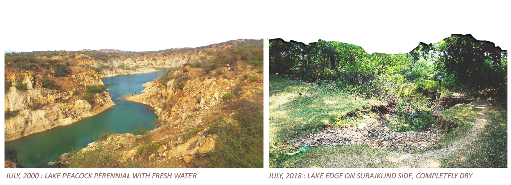
The striking contrast in the two images above depict the unfortunate drying up of Lake Peacock. On the left side is the Perennial lake during year 2000. Deforestation, mining , illegal encroachments, rapid urbanisation, rainfall reduction has lead to a drastic drying up of lake, that still continues till present.
LAKE PEACOCK RUNOFF- WATERSHED ANALYSIS

The current analysis of runoff potential of watershed area indicates that there are number of local drainage generated from Aravalli area to Surajkund Lake .However, the density of discharge seems to be very low as compared to watershed area of Surajkund Lake which is the main concern of the present watershed and drainage system. In totality, the runoff was generated as 6.2 m3. However, it is found that the area is highly disturbed by the construction of urbanization projects such as roads, bunding and houses which has disturbed the runoff and only 25-30 % of the runoff remains for the replenishment of Surajkund Lake which may be taken as 2.7-3m3 as a final total runoff to reach Surajkund Lake. In this way, it may be analysed that the runoff for the watershed area are good enough for the Surajkund Lake with the help of training of drainage system using the innovative technique such as continuous connectivity of the small reservoir of mining and provision of aqueducts or subsurface waterways from the tangent of the watershed in order to replenish the Surajkund Lake. (3)
Seasonal response of Surajkund Lake’s original extent occupies a vast area of 137.07acres in which the remaining wet area has been analysed as 40.51 acres which clearly indicates that about 29% of the area remains as wet area. This is because of the urbanization factors such as roads and settlements around Surajkund Lake area.
In all it seems that the total runoff generated by the watershed nearby lake is about 6.2 m3 and the total requirement of all zones is about 5.30m3 .It is clear from the runoff calculation and water requirement calculation that almost 1 m3 extra amount of water has been generated by the watershed of Surajkund Lake .Also, taking 50% due to seepage ,evaporation and evapotranspiration even then the requisite amount of rainfall runoff is available to the watershed of the Surajkund Lake area which proves that the revitalization of Surajkund Lake is possible with careful engineering design . (3)
THE ANANGPUR DAM – MINING & ILLEGAL ENCROACHMENTS
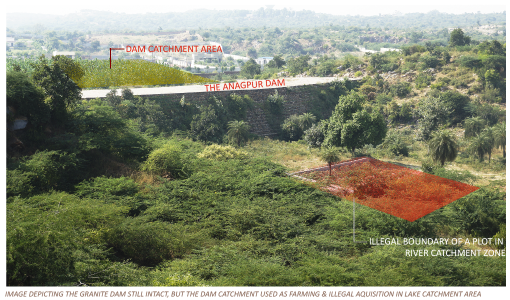
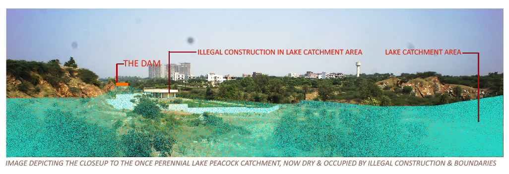
The Anangpur dam, once utilized as a first effective dam in the region (made completely of Quartzite stone masonry & still the only exiting earliest stone dam in Delhi- NCR), has now been overtaken by the farmlands adjacent to the dam. The rain- water was harvested here by constructing it across the mouth of a narrow ravine. This bund resulted in impounding waters & creating a vast lake which raised & sustained subsoil water table in the area, including that of SurajKund. The sluice openings in the dam allowed controlled volumes of water to flow through the ravine & irrigate the fields below. The illegal farming in the catchment area of the dam has resulted in nil water capturing during the monsoons, as water seeps into the agricultural soil. This current situation is further worsened by the Unauthorized acquisition of lands for farmhouses & other land uses on the lake catchment area, by the influential folks, resulting in a distress. This has lead to a break in chain of water movement from dam to the kund. As a result, the kund is dry, the lake is dry & so is the dam. The once meticulous & calculative construction of the Tomar Dynasty’s earliest waterworks masterpiece is now in peril.
This Waterwork system is the greatest & earliest Landscape jewel of the Ridge region & the whole Mughal era in this region has left great marks on the subsequent development& restoration of this marvel. It is the utmost duty of us as the citizens & the government authorities to overlook it as the utmost matter of a landscape emergency and to impose strict guidelines & regulations with measures to bring this landscape waterworks art back to life.


FAILED EFFORTS FOR RESTORATION
The Court’s direction for revival dtaes back to their first statement in 1996 : In October 1996, the SC directed that “no construction of any type shall be permitted then onwards within 5 km radius of the Badkhal lake and Surajkund” lakes in Haryana. SC ordered the Haryana government to construct a 200-metre-wide green belt along Surajkund and Badkhal. Further the SC stated that no mining lease should be renewed in the 2-5 km radius unless a no-objection certificate (NOC) is obtained from Central Pollution Control Board (CPCB) and Haryana Pollution Control Board. However, mining is such as flourishing and lucrative economic activity that mining continues unabated with the blessings of the government. This, further worsened in 2000 & further years where NGT & other authorities have time & again regulated certain strict implementations, but all that went ignored as the wealthy & influential still continue to degrade the already extinguished historical cultural waterscape.
This is an excerpt from the hearing of the above case, providing a legal evidence on impact of mining on lakes, which after enough deliberation of years of several government & local bodies , is still a failure :
BOX: Impact of mining on the lakes: Evidence The impact of mining on the lakes and groundwater has been repeatedly brought out in unambiguous terms by several committees.
- 2002:Ridge Management Board of the Delhi government in an intervening petition in the M C Mehta case once again asked for a ban on mining which was causing decline in groundwater levels. The Supreme Court gave a ban order on all mining activities along a 5 km stretch from the Delhi border, specifically banning pumping of groundwater.
- 2004: The Central Groundwater Board submitted a report to the Supreme Court stating that the drainage pattern of the area has been modified due to haphazard mining and dumping of waste material.
- 2006: M C Mehta approached the Court once again stating the court orders are not being complied with. The Court-appointed fact-finding Committee showed the devastating impacts of mining on the ecology and water bodies.
- 2008: The Chandigarh office of the Central Ground Water Board submitted a hydrological report before the Forest Bench of the Supreme Court saying that mining pits reached below the aquifer and there was massive evaporation of groundwater to the tune of 886, 891 cubic meter of groundwater each year. The report also added that there was pumping out of huge amounts of groundwater by the mining companies.
Still, the mining continues & haphazard urbanization by the wealthy & influential community, just next to this historical cultural waterworks continue till date. The most recent encroachments & illegal zones includes the group housing towers established in name sake of lake view, right next to the lake edge, one of thembeing the Lakewood City, right on the edge of lake, overlooking it.
The pace of urbanization has disturbed the Delhi ridge in general and the catchment in particular by virtue of which the water bodies of historical importance started vanishing. The matter became more worse with the advent of new drilling technology such as Down Throw Hammer which drills the tube wells quite deep in the hard rock area .With the development and growth of population in and around Delhi ridge and in historical water bodies the rate of abstraction of groundwater gradually increased by virtue of which the grated gravel in and around historical water bodies started declining. As a result water table goes very deep and seepage losses from these water bodies gradually increased with the pace of declining water level. In this way the water shed declining of water bodies and seepage losses both are responsible for deterioration of water level of historical importance such as Surajkund Lake which has shrunken about 25-29% of its original Shape The Surajkund Lake is located in Faridabad District and it is the most important tourist place maintained by Haryana tourism. Since the area in SurajkundLakel area is surrounded by Tilput range of hard Quartzite terrain and therefore any water body of this magnitude will provide the thermal comfort to the nearby residential zones & reduce the heat island effect considerably. The Surajkund Lake area is originally occupied by 137.07 acres has been shrunk to 40.51 acres .Surajkund Lake is one of the prominent water bodies in Faridabad and is deteriorating because of the disturbed catchment and watershed due to mining and urbanization.
Thus, it is an urgent need of the hour to take necessary steps as the citizens of country & by the local folks of the region, to contribute in re-establishing of this historical waterworks system, which is a cultural & historical landscape identity of Ridge zone &Aravallis. Revival of this will not only boost the tourism & revival of cultural identity of our waterscape, but also provide the locals with loads of climatic & geophysical benefits like – restoration of water table, reduction in dependency of nearby villages on tank water, reduction of extreme temperatures during summers, reduction in pollution through afforestation, increase in annual rainfall of region, reduction in soil erosion & dust particles in air, reduction in heat- island effect & protection from harsh dust storms from nearby south- western regions.
REFERENCES :
(1) James L. Wescoat Jr. – Aga Khan Program for Islamic Architecture of MIT- October 8 , 2011, THE WATER AND LANDSCAPE HERITAGE OF MUGHAL DELHI
(2) Cherian , 2004 , Pairing Mega events and Hydrological Systems for Urban Sustainability , Strategy Framework for Delhi beyond the Commonwealth Games 2010
(3) Syed Rehan Ali, Analysis of sustainability of Surajkund Lake and determination of hydrodynamics of Delhi ridge with special reference to urbanization impact assessment
FOR DETAILED INSIGHT TO OUR LANDSCAPE PROJECTS, VISIT : https://gngindia.com/architects/landscape/
Developed by Abacus Desk

